 |
|||||||||||||||||||||||||
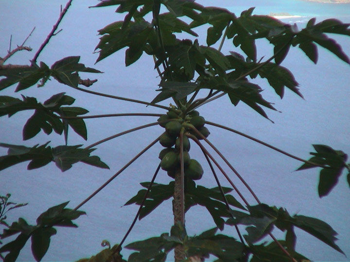
We are back in the British Virgin Islands! When we first arrived in the Virgin Islands for the start of our expedition (Day 1) we flew in to Tortola late at night and left early the next morning. This time we will have a chance to explore Tortola. The name for Tortola is from the Spanish word for "turtle dove". Yorktown Clipper is docked at Road Town. Road Town is the center of government in the BVIs. It is also the biggest city in all of the BVIs, but it is probably not as big as your town. Most of the 16,630 people living on Tortola live in Road Town. (How many people live in your town?) Tortola has an important connection to the United States. About 15 years after the American Revolutionary War, a man (William Thornton) from Tortola designed the U.S. Capitol Building in Washington, D.C.! Today we are going to visit the tallest mountain in all the Virgin Islands -- Sage Mountain (1,716 feet). Sage Mountain is a National Park. This National Park protects the last remaining tropical forest on Tortola. Like on St. John, yesterday, our taxi is an open air taxi. Our driver and guide is Carl. Carl is from St. Vincent, another Caribbean Island. (We visited St. Vincent on our Caribbean Sea Expedition.) As Carl slowly zigzags up the narrow mountain road we can see Road Town below us. In the distance we can see Peter Island. (Tomorrow we will be snorkeling to explore the coral reef off Peter Island.) Next to Peter Island is another island called Dead Chest Island. (A "dead chest" is a coffin.) Carl tells us that Blackbeard the Pirate marooned 15 of his men on the island to fight over a treasure chest. When he returned a week later they had all killed each other and Blackbeard kept the treasure. There is an old song about this: "Fifteen men and a dead man's chest. Yo-ho-ho and a bottle of rum!" After a 30 minute drive the road stops at the start of the trail to Sage Mountain. This trail is not as steep and difficult as the trail we climbed to the top of Gorda Peak on Virgin Gorda (Day 11). Along the way Carl points out some of the plants we see around us. No deadly manchineel trees up here. The manchineel trees that Rodney showed us yesterday only grow near the sea. Carl points out a tree with green fruit that is safe to eat. It is a papaya tree. (You can usually find papayas in your local supermarket.) Papayas are green on the outside turning orange as they ripen. The inside is a red-orange and they are sweet to eat and taste so good!
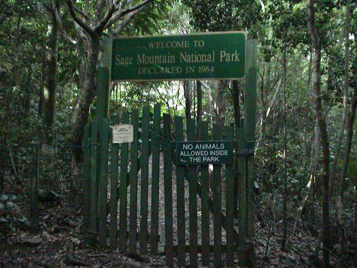
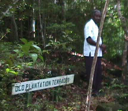
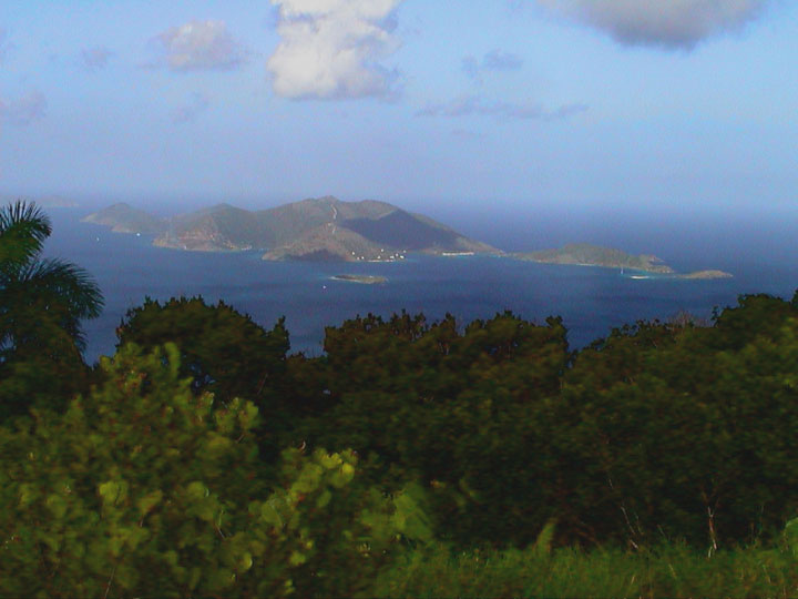
We continue hiking up the trail and see more trees with edible fruit, such as mangos, breadfruit and coconuts. After hiking for 10 minutes we arrive at the gate to the Sage Mountain National Park. On the green wooden gate is a funny sign. We don't think it was put on the gate as a joke, though. It says "No animals allowed inside the Park." We wonder if the birds, lizards, and snakes know this! Inside the gate the trail gets narrower, but it is still not as steep and rocky as the Gorda Peak trail. We are in a forest. Like the forest we explored on Virgin Gorda (DAY 11), this is not a rain forest. Even though we are the tropics the rainfall here is less than 100 inches each year. This may be more rain than where you live, but it is less than the rainfall in a true tropical "rain forest". (Check to find out much rainfall your area gets each year.) At a bend in the trail Carl shows us some old stone walls. Like St. John, Tortola was dug up and made into sugar and cotton plantations. The plantation owners terraced the sides of the steep hills to grown their crops. The small stone walls are the sides of the old terraces. The sugar cane and cotton plants are all gone now and the forest plants have overgrown everything. Carl takes us to a lookout at the highest point on Sage Mountain. We can see all the Virgin Islands! Carl points out the island closest to Tortola. This small island is called Jost Van Dyke. Carl tells us it is named for an old Dutch pirate!
It is time to hike back down to the taxi and return to the Yorktown. Even though the Spanish explorers saw lots of turtle doves on Tortola, we didn't see any at Sage Mountain. We did see a hummingbird fly by, though. We think the turtle doves probably read the sign on the gate. We should see lots of animals tomorrow. Join us tomorrow when we spend the day exploring the underwater coral reef at Peter Island! Best Fishes, |
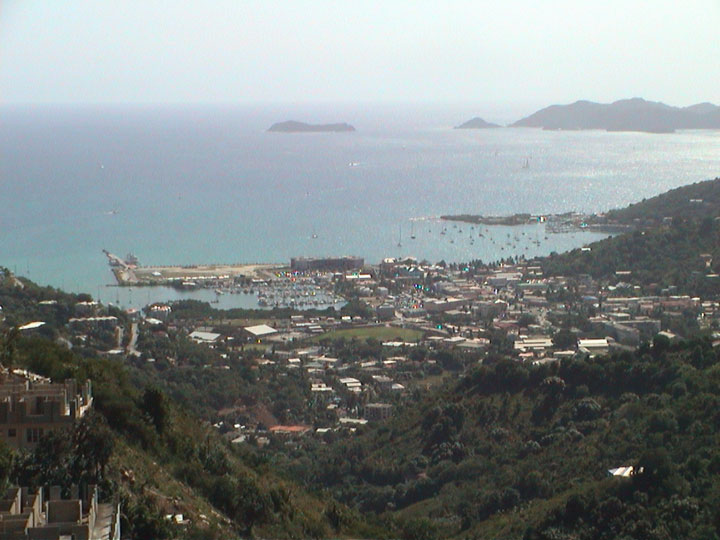
TODAY'S DATA Road Town, Tortola Island, British Virgin Islands Position: 18º 23' N / 64º 42' W Cruz Bay, St. John, USVI. Yorktown Clipper at the dock that sticks out on the left side of the picture. (In the distance the large island is Peter Island. The smaller island is Dead Chest Island.)
We can see papayas growing at the top of this papaya tree.
This gate is the entrance to Sage Mountain National Park. We thought the sign on the gate was funny. (Enlarge the picture to see the sign.) It says "No animals allowed." We wonder if the birds, lizards and snakes know this!
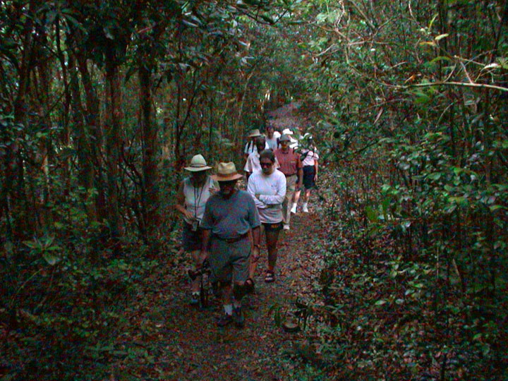
Our hike along the Sage Mountain trail is surrounded and covered by trees, bushes and other plants.
Carl shows us the small walls of the old plantation terraces. The crops are gone and the forest plants have overgrown everything.
From the top of Sage Mountain we see the island, Jost Van Dyke. It is named for an old Dutch pirate! |
||||||||||||||||||||||||
home | basecamp | archives | library | other expeditions | kids' page | contact us © 2003, The Ocean Adventure All rights reserved. |