British Virgin Islands Facts
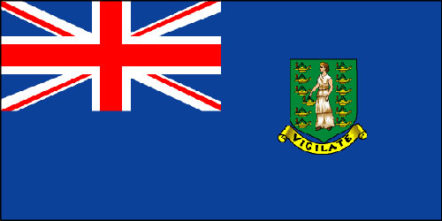
Flag Description: The flag of the United Kingdom (England) is in the upper left corner. The Virgin Islander coat of arms is centered is on the right. The coat of arms has the Latin word "vigilate" ("Be Watchful") and shows St. Ursula holding an oil lamp and surrounded by another 11 oil lamps. Columbus named the Virgin Islands after St. Ursula and her 11, 000 martyred virgins. On the flag St. Ursula is surrounded by 11 oil lamps representing the 11,000 martyred virgins of Christian belief.
• History: First inhabited by Arawaks, then Caribs. Discovered by Columbus in 1493.
First settled by the Dutch in 1648. Annexed by England in 1672.
• Owned by: England (United Kingdom) - overseas territory of the UK
• Government: British - Queen is head and appoints island Governor.
Local government is elected Legislative Council with 13 members.
• Capitol: Road Town, Tortola
• Number of Islands: 16 inhabited islands with 3 main islands, and 70 cays
• Area: 153 square kilometers
• Amount of Coastline: 80 km
• Highest Point: Mount Sage, Tortola - 521 meters
• Average Temperatures: Winter - 77ºF / Summer 82ºF
• Population: 21,272 (2002 est.)
• People: African descent, British mainland, Indian, Asian, other British Caribbean islands
• Language: English, plus some Creole, Spanish and French
• Religion: Protestant - 86%, Catholic - 10%
• Literacy (people over 15 that can read and write): 97.8%
• GDP (Gross Domestic Product): $311 million US Dollars (2000 est.)
• GDP - per capita: $16,000 (2000 est.)
• Industries: Tourism, light industry, construction, rum, concrete block, banking
• Agriculture: fruits, vegetables, livestock, poultry, fish
• Exports: $6.2 million US Dollars (2002 est.)
rum, fresh fish, fruits, animals, gravel, sand
• Imports: $230 million US Dollars (2000 est.)
building materials, automobiles, foodstuffs, machinery
• Major Trading Parter: United States
• Currency: US Dollar
• Television stations: 1 broadcast (plus 1 cable company)
• Radio stations: 1 AM, 4 FM
• Roads: 177 km paved, 177 km unpaved
• Ship Ports: 1 - Roadtown
• Airports: 3
|
|
|